
Project

AnythingPOI: a fused, confidence-scored points of interest dataset

OpenStreetMap and Overture Maps conflated into one deduplicated, classified, openly licensed dataset. 22.7M points across six countries, every record carrying a confidence score and the evidence behind it.

Period

2026 to present

Status

Active

Role

Author and lead developer

Areas

OpenStreetMap · Overture Maps · H3 · DuckDB · GeoParquet · PMTiles · Open data

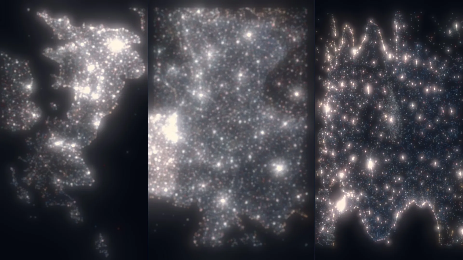
Three countries rendered as dense constellations of white points against black, each point a place of interest, with cities showing as bright clusters.
Figure

Three of the six national datasets, drawn as their own points. Settlement structure emerges without any basemap underneath, because at this density the places are the map.

  • 22.7MPoints of interestFused from OpenStreetMap and Overture Maps across six countries, deduplicated and individually scored.
  • 6Countries releasedGermany, Canada, the United Kingdom, Türkiye, the Netherlands and Australia, each published as a citable versioned dataset.
  • 545kCross-source matchesRecords independently confirmed by both sources under a 50 m gate, category agreement and 0.85 name similarity.
  • 93%Wikidata match rateOn conflated pairs. A QID is the strongest single confidence signal in the scoring model, worth +0.15.

The brief

Two open datasets describe the world’s points of interest and neither is sufficient alone. OpenStreetMap is community-verified and often hand-tagged, with strong geographic fidelity and real gaps in commercial coverage. Overture Maps, backed by Meta, Microsoft, Amazon and TomTom, has commercial-scale breadth and lacks the granular tagging and human verification that makes OSM trustworthy.

Anyone who needs both ends up doing the same work: pull two extracts, discover they disagree about where things are and what to call them, write matching logic, and produce a merged file that nobody else can reproduce or check. The result is a private dataset with private assumptions, rebuilt from scratch by the next person who needs one.

AnythingPOI does that fusion once, in the open, and publishes both the output and the pipeline. 22.7 million records across six countries, every one deduplicated, classified against a shared taxonomy, and carrying a confidence score you can interrogate.

The insight

The useful decision was to make the pipeline conservative and then say so loudly, rather than optimising for an impressive-looking match rate.

Conflation is where this kind of project usually oversells. Loosen the thresholds and the merged count climbs, which reads as success and quietly fuses two different businesses that happen to share a name and a street. Tighten them and the match rate looks unimpressive. AnythingPOI takes the second path: a hard 50 m gate, required category agreement, and 0.85 name similarity, all three of which must hold. The result is that cross-source matches run between 1.4 and 3.2 percent by country.

That number is low and it is honest. A match here means two independent datasets agree, which is why dual-source corroboration is worth something in the confidence score at all. Inflating it would have destroyed the signal it exists to provide.

The per-country pattern is itself informative:

CountryTotal POIsConflatedOSM share
Germany6,763,7963.2%35.8%
Canada5,565,2561.4%8.1%
United Kingdom4,622,1742.7%20.5%
Türkiye2,201,3041.4%13.9%
Netherlands1,782,5382.8%15.8%
Australia1,735,9803.0%18.4%

Germany and the UK carry the richest community mapping and the highest conflation rates, which is what you would expect and is worth being able to demonstrate rather than assume.

The second decision was to score every record individually instead of publishing a clean subset. A dataset that silently drops uncertain records looks better and tells the user less. Scoring keeps everything and hands the filtering decision to whoever knows their own tolerance.

What it does not do

Each release is a snapshot. OSM and Overture are live, and the fused output describes the moment the pipeline ran, which is why releases are versioned and citable rather than continuously updated.

Conflation recall is the known weakness, and it follows directly from the conservative thresholds. Real duplicates with transliterated names, address-only correspondences, or a large polygon whose centroid sits far from its entrance will not be caught. Recall is the price of precision here, paid deliberately.

Every output record is a point. A park or a shopping centre becomes its centroid, which is wrong in a way that matters for anything measuring area or containment. Address completeness varies enormously by country and category: around 42 percent street coverage for Parks and Nature against roughly 97 percent for Healthcare in Canada. And names are stored exactly as they appear in source data, with no transliteration or translation, so cross-script querying is left to the user.
How it works

5 stages
  1. 01

    Ingest from two sources with opposite strengths

    OSM PBF extracts are parsed with a streaming PyOsmium handler that accepts any named or branded feature and rejects primary tags on a non-POI blocklist. Overture places are pulled through DuckDB straight from the public S3 release, with the bounding box pushed down into the Parquet predicate.

    Ways and relations resolve to centroids via WKBFactory and Shapely. PBFs over 1.5 GB are clipped with osmconvert first, cutting parse time by 60 to 90 percent.

  2. 02

    Block spatially before comparing anything

    Every record is assigned an H3 index at resolution 11, roughly a 24 m edge. Candidates are then compared only within a cell and its six neighbours, which is what makes the problem tractable: comparing all pairs globally is quadratic and hopeless at this scale.

    Four to five orders of magnitude fewer comparisons, while still guaranteeing that any two features within about 150 m of each other are evaluated against one another.

  3. 03

    Match on three gates, not a similarity score

    A pair must clear all three: Haversine distance under 50 m, agreement on Tier-1 category through the taxonomy crosswalk, and Jaro-Winkler name similarity of at least 0.85 on normalised names. The highest-scoring surviving candidate wins, and each Overture record can claim at most one OSM record.

    Deliberately conservative. Matching thresholds this tight mean the pipeline under-claims rather than fusing two different shops into one plausible-looking record.

  4. 04

    Score every record, and say why

    Confidence starts at 0.5 and moves on evidence. A Wikidata QID adds 0.15, dual-source corroboration 0.05, and website, phone, address and opening hours add smaller amounts. A digit-only name subtracts 0.15, a name that is actually a URL subtracts 0.10.

    Observed distribution across the current release: mean 0.734, median 0.73, IQR 0.68 to 0.79. Only 0.2 percent of records fall below 0.5, and 15 percent reach 0.8 or higher.

  5. 05

    Publish for analysis and for the browser

    Output is written twice. Cloud-optimised GeoParquet, one file per Tier-1 category, sorted by H3 cell for spatial locality and readable by GeoPandas, DuckDB or QGIS. And a PMTiles v3 archive banded across four zoom ranges so a national view loads only the highest-confidence records.

    18 GeoParquet files, 35 columns each, Snappy compressed. Tiles run z4 to z16, with the national band filtered to confidence 0.7 and above.

Figures

Fig. 1

The explorer. Zoom bands are the reason a national view stays responsive: at z4 to z6 only the highest-confidence records are carried, and the full dataset with all attributes appears only at street level.

Fig. 2

One dataset, several readings, over Toronto. Because confidence, source and category all travel with each record into the tiles, the rendering can be driven by any of them without going back to the pipeline.

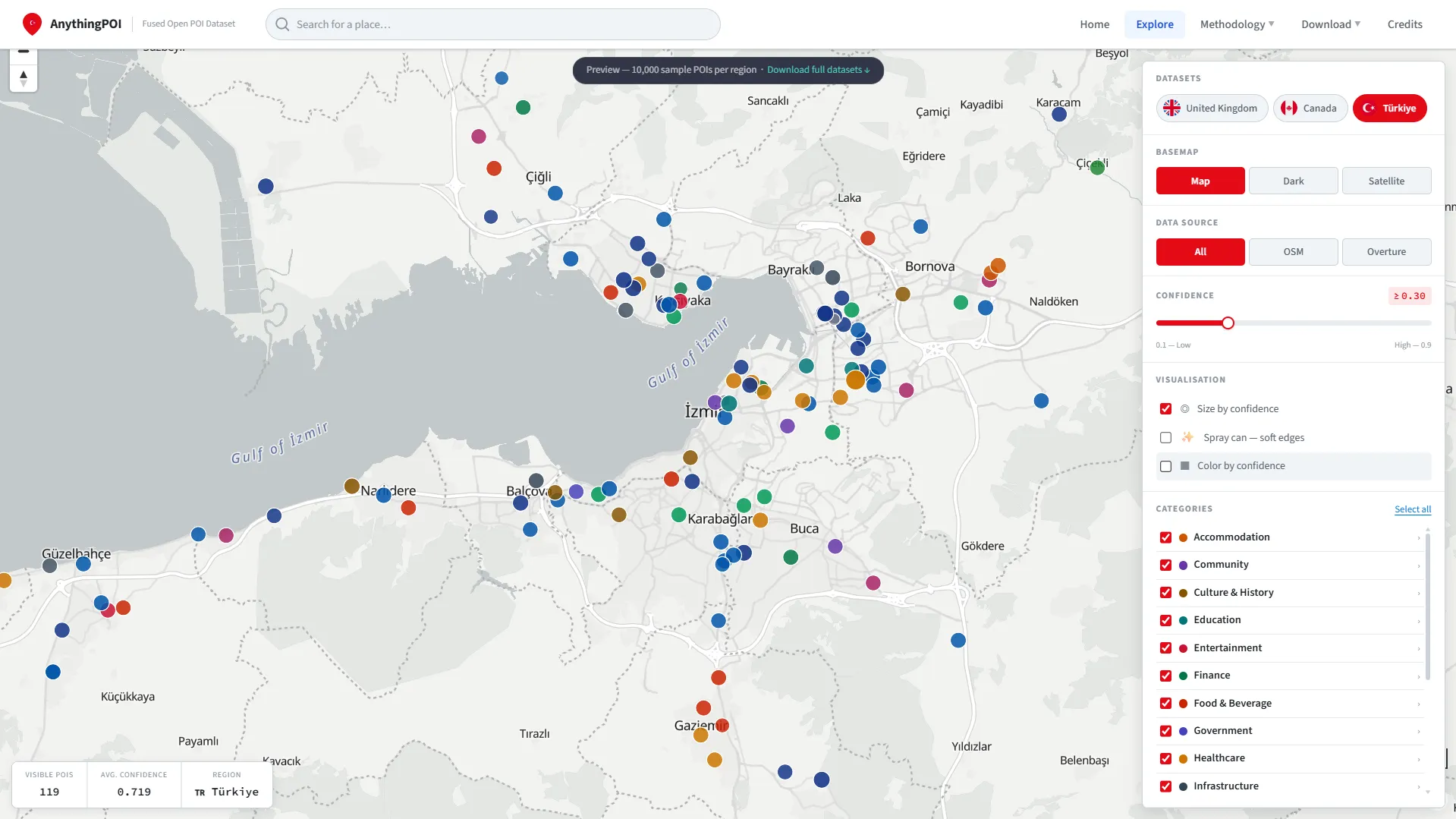
The AnythingPOI web interface showing the Türkiye dataset with category and attribute panels.
Fig. 3

Türkiye, 2.2M records. Each country is processed by the same region-agnostic pipeline, so adding one is a matter of an OSM extract and an Overture bounding box rather than new code.

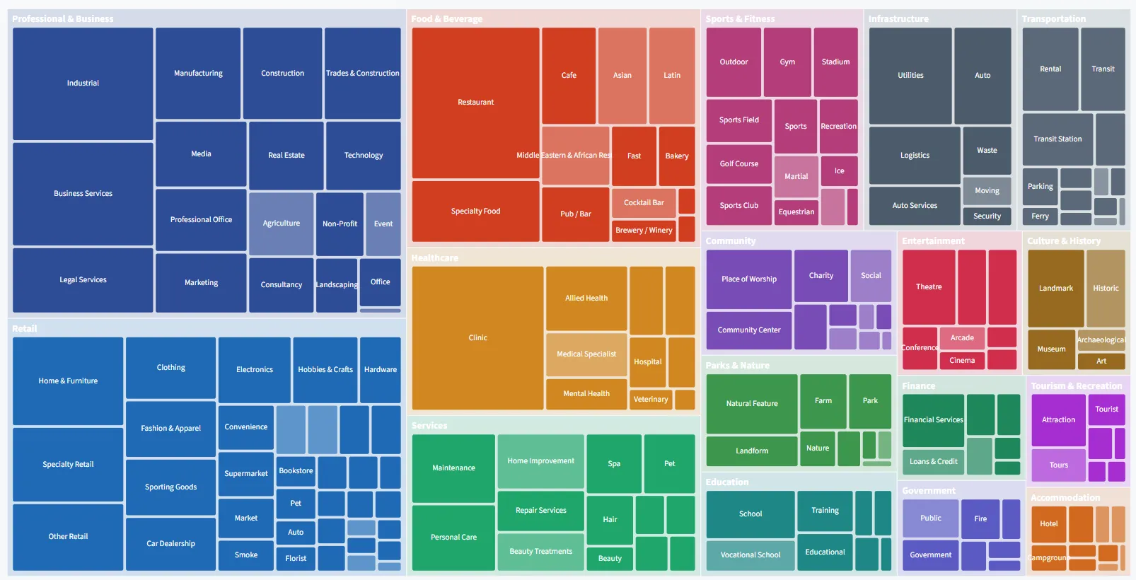
The AnythingPOI taxonomy browser showing Tier-1 categories and their Tier-2 subcategories.
Fig. 4

The taxonomy: 17 Tier-1 categories over 196 subcategories, fed by 577 OSM rules and 1,539 Overture rules. Anything matching no rule is recorded as unclassified rather than forced into an approximate bucket.

Outcomes

  • Six national datasets, openly citable

    Germany, Canada, the UK, Türkiye, the Netherlands and Australia are each released as a versioned dataset with a DOI, so a paper can cite the exact snapshot it used rather than a moving target.

  • A confidence score with its working shown

    Every record carries not just a number but the signals that produced it, including per-attribute match flags for conflated pairs. A downstream user can filter on confidence or reconstruct the reasoning and disagree with it.

  • Two vocabularies reconciled

    OSM tags and Overture category strings describe the world differently. 2,116 classification rules map both onto one two-level hierarchy, which is what makes category agreement usable as a matching gate rather than a source of false pairs.

  • Reproducible without a single API key

    Ingestion, conflation, scoring and tile generation all run from open source code against public data. A full country takes roughly two to four hours on a sixteen-core machine, and anyone can rerun it.

Stack

Ingestion
PyOsmium, DuckDB, Geofabrik, osmconvert, Shapely
Conflation
H3 resolution 11, Jaro-Winkler, Haversine 50 m gate, Taxonomy crosswalk
Output
Cloud-optimised GeoParquet, PMTiles v3, MVT z4 to z16, Snappy compression
Sources
OpenStreetMap (ODbL), Overture Maps Foundation (CDLA 2.0), Wikidata (CC0)
Scale
22.7M records, 2,116 classification rules, 18 category partitions, 2 to 4 hours per country
  • Leverhulme Centre for Research on Slavery in War
  • Rights Lab
  • University of Nottingham
  • King's College London

AnythingPOI is developed as part of the Leverhulme Centre for Research on Slavery in War, University of Nottingham, in partnership with King's College London. Data © OpenStreetMap contributors (ODbL) and © Overture Maps Foundation (CDLA Permissive 2.0), with verification signals from Wikidata (CC0).

Work like this

Start a
conversation →

Available for consulting engagements and research collaborations at this scale. Email james@jameswil.com.